
Identifying Aquifer Layers Using the Vertical Schlumberger Configuration Resistivity Geoelectric Method in the Permata Hijau Housing Complex, Koya Barat Village, Muara Tami District, Jayapura
DOI:
https://doi.org/10.31957/jfp.v4i1.212Keywords:
Akuifer, Metode Geolistrik, Resistivitas, Konfigurasi Schlumberger Vertical, Schlumberger, GeolistrikAbstract
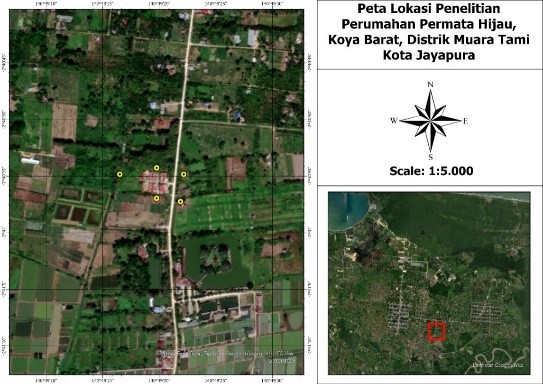
Research on identifying aquifer layers using the vertical Schlumberger Configuration Resistivity Geoelectric method was carried out in the Permata Hijau Housing Complex, Koya Barat Village, Muara Tami District, Jayapura City. This research aims to determine the resistivity, location and depth of the aquifer layer. The research methods used are field geophysical surveys and geophysical computing. The field geophysical survey method used is the geoelectric method. Field geophysical surveys, using the IREST300f resistivity meter, obtained other data on potential and electric current strength for field resistivity analysis. Computational geophysical methods provide the actual resistivity and vertical profile of soil layers. The number of vertical research points is 5 points. The research results show that there is an aquifer layer at each research point with variations in resistivity values, location and depth. The groundwater aquifer layers are vertical, namely at point 1 there are 2 free aquifer layers with resistivities of 3.34 Ωm and 1.65 Ωm. At point 2 there are 4 layers of unconfined aquifer with resistivities of 9.31 Ωm, 7.13 Ωm, 3.30 Ωm and 6.12 Ωm. At point 3 there are 3 layers of unconfined aquifer with resistivities of 5.61 Ωm, 3.00 Ωm and 1.61 Ωm. At point 4 there are 2 layers of unconfined aquifer with resistivities of 9.30 Ωm and 4.52 Ωm. At point 5 there are 3 unconfined aquifer layers with resistivities of 2.35 Ωm, 8.38 Ωm and 3.18 Ωm. The free aquifer layer is visible at point 1, found in layer 8 with a depth of 4.95-8.80 m and layer 10 with a depth of 19.20-24.00 m. The free aquifer layer is visible at point 2, found in layer 5 with a depth of 3.00-6.80 m and layer 7 with a depth of 16.10-20.00 m. layer 9 with a depth of 8.80-19.20 m and layer 11 6.12 Ωm with a depth of 53.00-76.00 m. The free aquifer layer is visible at point 3, found in Layer 5 with a depth of 3.40-6.00 m; layer 9 with a depth of 15.50-37.30 m; and layer 12 with a depth of 80.00-97.00. The free aquifer layer is visible at point 4, Layer 6 with a depth of 4.28-7.35 m. and Layer 10 with a depth of 50.00-57.40 m. The free aquifer layer is visible at point 5, Layer 4 with a depth of 5.31-5.65 m. Layer 8 has a depth of 15.50-39.00 m and layer 11 has a depth of 93.40-146.00 m.
References
Rusmiyati, C., & Hikmawati, E. (2012). Penanganan dampak sosial psikologis korban bencana Merapi. Sosio Informa, 17(2).
Nasution, F. Z. (2023). Penanganan dampak sosial psikologis korban bencana Merapi Gunung Sinabung. JUDIMAS, 3(2), 124-134.
Kurniawan, A., Ludiya, E., Yun, Y., & Fauzi, L. H. M. (2023). Optimalisasi Penerapan Hygiene Sanitasi Dan 5s Di Desa Wangun Jaya Kecamatan Cikalong Wetan Kabupaten Bandung Barat. Dinamisia: Jurnal Pengabdian Kepada Masyarakat, 7(3), 600-607.
Hidayatika. A., Annisa. R., Tiara., Suharno. (2021). Implementasi Metode Geolistrik dalam Identifikasi Akuifer Airtanah untuk Membantu Pemanfaatan Air Bersih di Kompleks Pondok Pesantren Nurul Huda Lampung Selatan. Seminar Nasional Keiiisinyuran (SNIP). 1 (l). 1-5.
Ikhwandi. A., Harnani. H. (2020). Identifikasi litologi untuk mengetahui lapisan akuifer dengan metode geolistrik di desa air batu, banyuasin, sumatera selatan. Prosiding Seminar Nasional. 4-720.
Widada, S., Satriadi, A., & Rochaddi, B. (2017). Kajian Potensi Air Tanah Berdasarkan Data Geolistrik Resistiviti Untuk Antisipasi Kekeringan Di Wilayah Pesisir Kangkung, Kabupaten Kendal, Privinsi Jawa Tengah. Jurnal Kelautan Tropis, 20(1), 35-41.
Soedireja, H. R. (2017). Potensi dan upaya pemanfaatan air tanah untuk irigasi lahan kering di Nusa Tenggara. Jurnal Irigasi, 11(2), 67-80.
Widiyanto, A. F., Yuniarno, S., & Kuswanto, K. (2015). Polusi air tanah akibat limbah industri dan limbah rumah tangga. Jurnal Kesehatan Masyarakat, 10(2), 246-254.
Widada, S., Satriadi, A., & Rochaddi, B. (2017). Kajian Potensi Air Tanah Berdasarkan Data Geolistrik Resistiviti Untuk Antisipasi Kekeringan Di Wilayah Pesisir Kangkung, Kabupaten Kendal, Privinsi Jawa Tengah. Jurnal Kelautan Tropis, 20(1), 35-41.
Naryanto, H, S., Khaerani, P.,Trisnafiah. S., Shomim, A, F., Wisyanto., Tejakusuma, Iwan. G. (2020). Identifikasi Potensi Airtanah untuk Kebutuhan Penyediaan Air Bersih dengan Metode Geolistrik: Studi Kasus di Kawasan Geostech, Puspiptek Serpong. Pusat Teknologi Reduksi Risiko Bencana (PTRRB), Kedeputian TPSA, Badan Pengkajian dan Penerapan Teknologi (BPPT) Gedung Geostech, Lantai I, Kawasan Puspiptek Serpong, Tangerang Selatan. 21(2). 204-212.
Nasrullah, A., Widodo, S., Bakri, H., & Umar, E. P. (2018). Pendugaan Potensi Air Tanah Menggunakan Geolistrik Tahanan Jenis Daerah Pesisir Kabupaten Luwu Provinsi Sulawesi Selatan. Jurnal geomine, 6(2), 60-64.
Usman, B., Manrulu, R. H., Nurfalaq, A., & Rohayu, E. (2017). Identifikasi Akuifer Air Tanah Kota Palopo Menggunakan Metode Geolistrik Tahanan Jenis Konfigurasi Schlumberger. Jurnal Fisika Flux: Jurnal Ilmiah Fisika FMIPA Universitas Lambung Mangkurat, 14(2), 65-72.
Sutasoma, M., Azhari, A. P., & Arisalwadi, M. (2018). Identifikasi air tanah dengan metode geolistrik resistivitas konfigurasi Schlumberger di Candi Dasa Provinsi Bali. Konstan-Jurnal Fisika Dan Pendidikan Fisika, 3(2), 58-65.
Amin, M., Tambun, B., & Halawa, A. (2023). Identifikasi Lapisan Aquifer Berdasarkan Metoda Geolistrik Konfigurasi Wenner Schlumberger Di Desa Petuaran Hilir Kecamatan Pegajahan Kabupaten Serdang Bedagai. Jurnal Teknologi, Informasi dan Industri, 3(2).
Mantiri, S. Y. Y., Lunga, N., Resa, R. A., & Napitupulu, D. (2024). Identifikasi Lapisan Tanah Mengandung Gas Biogenik Menggunakan Metode Geolistrik Resistivitas Schlumberger Vertikal di Kampung Bugis Holtekamp, Distrik Muara Tami, Kota Jayapura. Journal of Health, Education, Economics, Science, and Technology (J-HEST), 7(1), 140-148.
Downloads
Published
Issue
Section
License
Copyright (c) 2025 This license allows reusers to distribute, remix, adapt, and build upon the material in any medium or format, so long as attribution is given to the creator.

This work is licensed under a Creative Commons Attribution-ShareAlike 4.0 International License.
![]()

